Lake Agassiz
Vast prehistoric lake
Online Biology Dictionary
|
|
EUGENE M. MCCARTHY, PHD
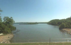 Southern end of Lake Traverse, site of Lake Agassiz's former southern outlet.
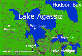
Lake Agassiz was an immense lake that existed in north-central North America during the last ice age. It is named for Louis Agassiz, the first scientist to realize it had been created by glaciers acting as dams. Larger than many modern seas, its waters were fresh, not salt. At its greatest extent it covered an area larger than California (see map right) and held more water than is today contained in all the freshwater lakes of the world combined.
When ice still blocked its outflow to the north, it had a southern outlet through a valley that today lies on the South Dakota-Minnesota border, now occupied by Lake Traverse, which forms the southernmost extension of the Hudson Bay drainage basin (see map →).
This vast body of water drained and refilled, apparently, several times, but emptied finally and completely about 8,000 years ago, when the melting ice of Hudson Bay gave its waters egress. It is estimated that drainage of the lake raised world sea levels by one to three meters. Lakes Manitoba and Winnipeg, are residual catchments, which correspond to regions where the original lake was deepest. Though huge by modern standards, they retain only a small fraction Agassiz's original waters.
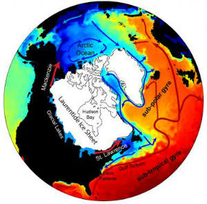 Map based on computer model of thermal effects of Lake Agassiz outbreak. Credit: Alan Condron, UMass Amherst
According to a recent study (Condron and Winsor 2012), a major initial outbreak of Lake Agassiz, about 13,000 years ago, drained north through the Mackenzie River into the Arctic Ocean, bringing about a sharp climate-cooling period in Europe and North America known as the Younger Dryas, or more familiarly as the "Big Freeze," (see figure above, right). Condon and Windsor state that
Most shared on Macroevolution.net:
Human Origins: Are we hybrids?
On the Origins of New Forms of Life
Mammalian Hybrids
Cat-rabbit Hybrids: Fact or fiction?
Famous Biologists
Dog-cow Hybrids
Georges Cuvier: A Biography
Prothero: A Rebuttal
Branches of Biology
Dog-fox Hybrids